
A widespread storm system, the fourth nor’easter in less than three weeks, is beginning to move in on the tri-state area, that could bring upwards of a foot of snow later Tuesday night and throughout the day Wednesday.
A winter storm warning has been issued ahead of the latest storm.
Clouds will increase Tuesday with some rain and wet snow making it into southern and central New Jersey Tuesday afternoon. Ironically, Spring begins at 12:15 pm on Tuesday.
The precipitation will initially be fighting dry air as it tries to move north, so snow or rain probably won’t begin until Tuesday night for New York City and points north. Expect a wintry mix as the precipitation begins, since mid-level temperatures are initially marginal for all snow.
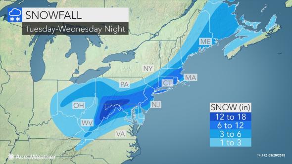
Projected totals rose sharply Monday, then increased again Tuesday afternoon: now, a widespread 8 to 12 inches is expected for New York City and most of the rest of the region, while the Hudson Valley and spots north and west should get closer to 4 to 8 inches. It’ll be heavy, wet snow, and that wet mess will test trees and power lines.
Travel will be very difficult to impossible, especially during the evening commute. Snow will develop during the morning and become heavy by afternoon. Expect significant reductions in visibility at times. A combination of the heavy snow and wind gusts up to 35 mph could bring down tree limbs and power lines, creating power outages.
· Light rain.
· Wintry mix and light to heavy snowfall is expected. The snow will be heavy and wet.
· Snowfall of 1.00 inch per hour for greater than 60 minutes is possible.
· Thunder snow is possible.
· Minor to moderate coastal flooding is expected, especially for Southern Queens during periods of high tide.
· Increasing winds, sustained winds: 20-30 mph, gusts 40-45 mph.
· A chance for rain after 2 PM eventually changing to all snow tonight by 11 PM.
· Snow will become steadier Wednesday morning around 8 AM.
· The heaviest period of snow will occur Wednesday from 2 PM to 10 PM.
· Thunder snow will most likely occur Wednesday from 2 PM to 10 PM.
· Winds will increase tonight and are expected to subside Friday morning.
· The strongest winds are expected all day long on Wednesday.
· There are three periods of greatest concern for coastal flooding during the high tide cycles tonight until tomorrow night.
SNOWFALL TOTALS
Expected Citywide Total: 12.00 to 15.00 inches.
Maximum High End Potential: 18.00 inches (10% chances)
TEMPERATURES (High/Low) & WIND CHILL VALUES
Today: 38/31, wind chill values between 20 and 30, and wind chill values 15 and 25 late.
· Wednesday: 33/32, wind chill values between 15 and 20, and wind chill values 20 and 25 late.
· Thursday: 42/31
(YWN World Headquarters – NYC)
 Join the official YWN WhatsApp status


3 Responses
Not to plagiarize anyone, but this sounds like it’s the Jews fault 🙂
Look what global warming is causing. At the rate things are going if we dont stop pollution soon we may be having snow storms in middle of the summer!!!!
What happened to the “false” notion of global warming? Why are we having MORE than the normal amounts of Noreasters?????