
� Blizzard Warnings issued for NYC, Philadelphia, Boston � impacting 40+ million people
� First Blizzard Warning for NYC since 2017
� 12�24 inches expected along the I-95 corridor
� Heaviest snow Sunday night into Monday morning, with rates up to 2�3 inches per hour
� Wind gusts 50�70 mph creating life-threatening whiteout conditions
� Governors in 6 states have declared States of Emergency
� Mandatory travel bans in NYC and other areas beginning Sunday evening
� 15,0000+ flights canceled; Amtrak modified service; NJ Transit suspending service
� The Garden State is currently the epicenter of utility disruptions in the Northeast. According to data from poweroutage.com, New Jersey is reporting over 22,900 customers without power.
� Heavy, wet snow and strong winds likely to cause widespread power outages
� 2�4 ft storm surge may cause moderate coastal flooding from Delaware Bay to Cape Cod
� NYC and Boston Public Schools canceled Monday classes; many other districts closing
This website�allows you to�track the progress of DSNY snow removal vehicles�by address. Note: A plowed or salted street will not show blacktop�immediately. To submit a service request, click�here�or call 311.
The city offers this caveat: Actual conditions may differ from this data at times due to weather conditions, construction projects, closures, or other events. The data also might be not updated consistently because of time, changing circumstances, sourcing, and the nature of collecting comprehensive information.
For more information, visit�nyc.gov/snow.
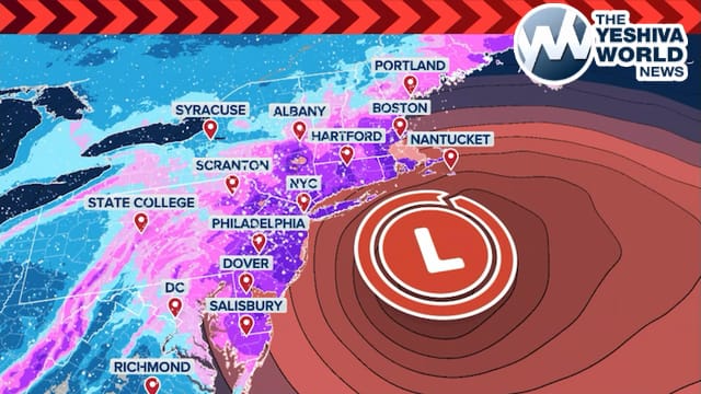
� Latest forecasts indicate this could be one of the strongest winter storms the NYC area has seen in years.
� Nearly the entire region is expected to receive 12�18 inches of snow between Sunday afternoon and Monday morning.
� Parts of Long Island, along with Monmouth and Ocean counties (LAKEWOOD, TOMS RIVER ETC) in New Jersey, could see up to 2 feet of snow.
� When these ferocious winds hit the expected 2-foot snow totals, visibility will drop to near zero in seconds.
Peak wind gust forecast through Monday:
Montauk: 60�70 mph (gusts to 75 mph possible)
New York City: 50�60 mph
Boston: 50�60 mph
Hartford: 50�60 mph
Philadelphia: 30�40 mph
Washington: 40�50 mph
The most extreme winds are expected along the immediate coast, where gusts could top 70 mph as the “L” (low pressure) center tracks just offshore.
??? NYC Declares State Of Emergency, Citywide Travel Ban Begins 9 PM
In a rare move, NYC Mayor Zohran Mamdani has declared a State of Emergency and instituted a citywide travel ban as the blizzard intensifies.
? Ban in Effect: 9:00 p.m. tonight through 12:00 p.m. Monday
? All city streets, highways, and bridges closed to non-emergency traffic
? Applies to cars, trucks, scooters, and e-bikes
? Only essential emergency and critical service vehicles exempt
Officials cite forecasts of up to 24 inches of snow and wind gusts near 60 mph. The measure is intended to prevent stranded motorists and allow 2,600 sanitation workers to clear vital routes.
SIGN UP NOW TO A YWN WHATSAPP COMMUNITY TO BE INFORMED OF THE LATEST DEVELOPMENTS IN LIVE TIME!
(YWN World Headquarters � NYC)
 Join the official YWN WhatsApp status


6 Responses
Trump just signed an Executive Order barring the snow from making landfall. The Supreme Court is deciding the legality of such an order. Trump might face charges if they against his order.
the title says 30 inches and the article says up to 2 feet.
2 feet is 24 inches
Please post tachlisdik information on how to prepare, not just expected snowfall measurements. EG flashlights, batteries, power up phones, water supply, medications, salt and shovels, a plan to check on elderly, etc.
farawaybubby, you are so right! Elderly are always worried when the weather impacts their reliance on others. Certainly now many are worried.
Gobal warming has finally been officially debunked as 1 HUGE false myth, & President Donald Trump ????”? has been proven so correct to have manifested so much disdain to all these false global warming organizations
Is this still getting updated?