Forecasters say expected snowfall totals have not changed significantly since this morning, though there is now a higher likelihood of snow transitioning to sleet and freezing rain Sunday afternoon � a factor that could limit overall snow accumulation for South Jersey and New York City.
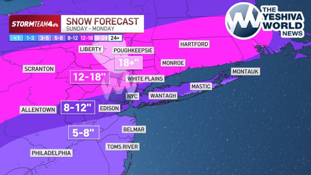
New York City is still projected to receive between 8 to 12 inches of snow, though meteorologists now believe totals may fall closer to the lower end of that range.
The heaviest snowfall is expected in higher elevations north of NYC, where conditions are forecast to remain all snow from Sunday through Monday morning. Areas around Poughkeepsie could see the highest accumulations, with 18 inches or more possible.
The Hudson Valley, Connecticut, and northern parts of New Jersey are forecast to receive between 12 to 18 inches of snow, while Central New Jersey and Long Island are expected to see similar totals to New York City.
South Jersey and the Jersey Shore are expected to see the lowest accumulations, though still significant, with totals ranging from 5 to 8 inches.
Once the storm moves out Monday, bitter cold air is expected to settle in for the entire week and into early February. Forecasters say this could mark New York City�s coldest sustained stretch below freezing since a two-week period in 2018.
(YWN World Headquarters – NYC)
 Join the official YWN WhatsApp status