
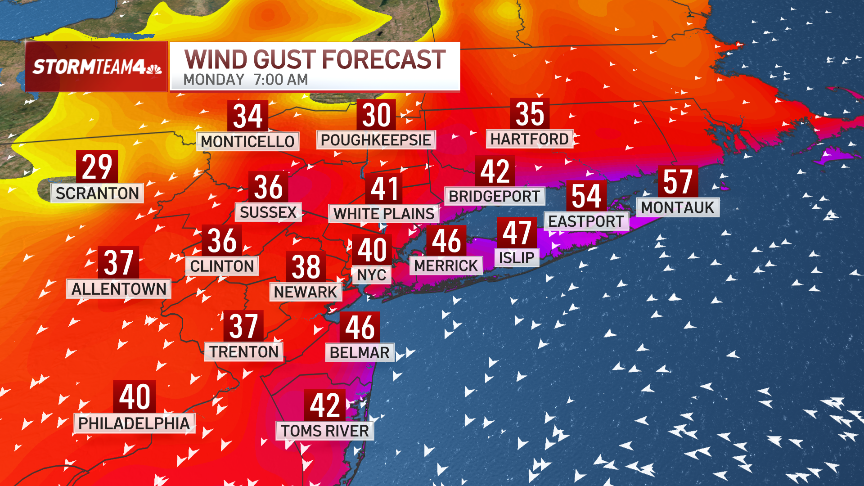
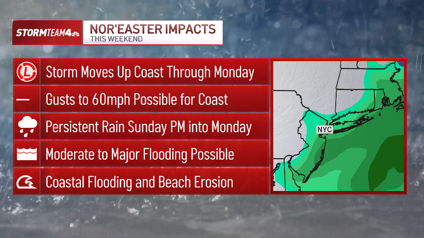
New York City, New Jersey could see wind gusts up to 60 mph by the Nor’easter crashing through the region Sunday into Monday, with rain persisting and “major” coastal flooding from towering waves possible across Long Island and down the length of Jersey, according to the latest forecasts.
Sustained winds began kicking up Sunday around 3 p.m., and on the coast will reach highs between 40 and 50 mph — but the gusts could reach even higher, according to Fox Weather.
Further inland, sustained winds between 30 and 40 mph are expected.
The winds will persist into Monday afternoon.
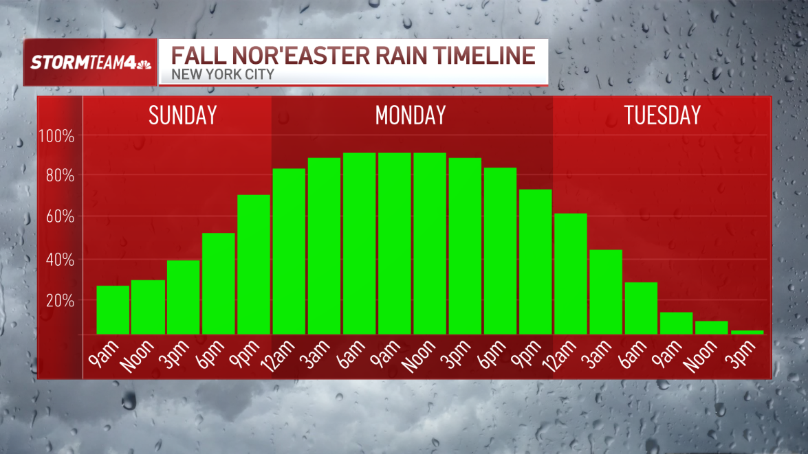
Rain will fall throughout Sunday afternoon into Monday morning — and while it remain generally light, periods of heavy rainfall could surge throughout.
About 2 inches of rain could fall across the region by Monday evening, according to Fox. Further north, the Boston area and south to Rhode Island could see up to 3 inches of rain.
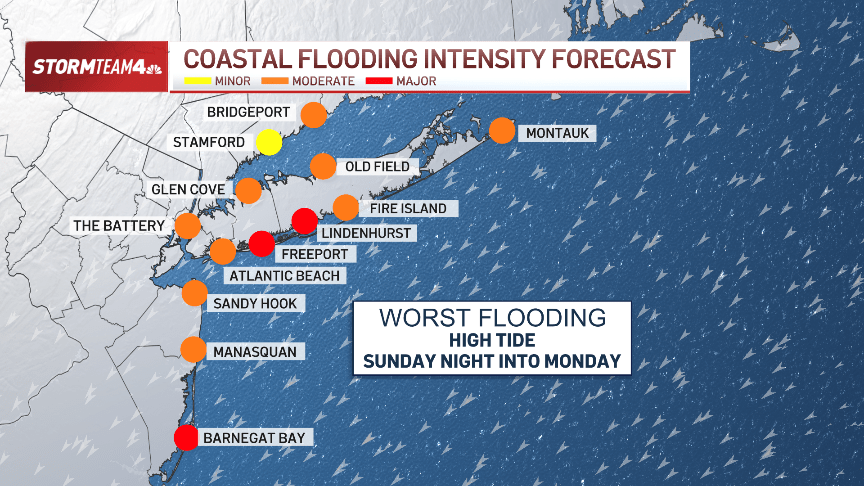
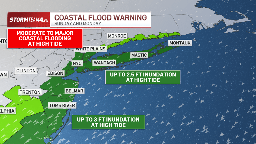
The worst of the flooding will come at the next two high tides — overnight at 12 a.m., and Monday afternoon at 12 p.m. — with surges of 3 feet possible, and waves as high as 15 feet crashing into the shores.
Inclement weather will have moved out by Tuesday, but gusts up to 25 mph could remain.
New Jersey’s acting governor, Tahesha Way, declared a state of emergency starting Saturday night in anticipation of the storm, saying parts of the state may experience major coastal flooding and up to 5 inches of rain.
Gov. Kathy Hochul said a swath of the state may be impacted, warning “major flooding” was possible across the South Shore of the Island and that rainfall could be “intense” all the way up to the Hudson Valley.
(YWN World Headquarters – NYC)
 Join the official YWN WhatsApp status


One Response
Fake news. We in NY have been inundated by a flood of texts, since Thursday, by supposed do-gooders who are advising people , with AUTHORITY- to take down their Sukkah because of the impending disaster of storm winds that were sure to wreak havoc and destruction everywhere.
But the terrible storm winds didn�t happen in the area I am in. There was rain that wouldn�t have been particularly noteworthy without all the hype. It waxed and waned and even stopped for a while. I bH sat in the sukka today.
Just like at least 50 percent of the time, the weather forecasters were mostly wrong regarding their dire predictions.
We are getting to the point that people don�t even stop to think if what they’re being told makes since, or even stopping to think, after the fact, if what they were told would happen actually came true.
Just keep looking at your phone, baby, and keep doing whatever they tell you!