
A winter storm warning has been issued for parts of Long Island and coastal New Jersey, while a winter storm watch has been issued for New York City, for a potentially significant snowfall Wednesday night and Thursday before arctic air comes roaring back on Friday.
A winter storm watch is in effect for New York City, Nassau County and parts of Connecticut.
Snow will move into the New York area late Wednesday night and early Thursday morning as a coastal storm heads north.
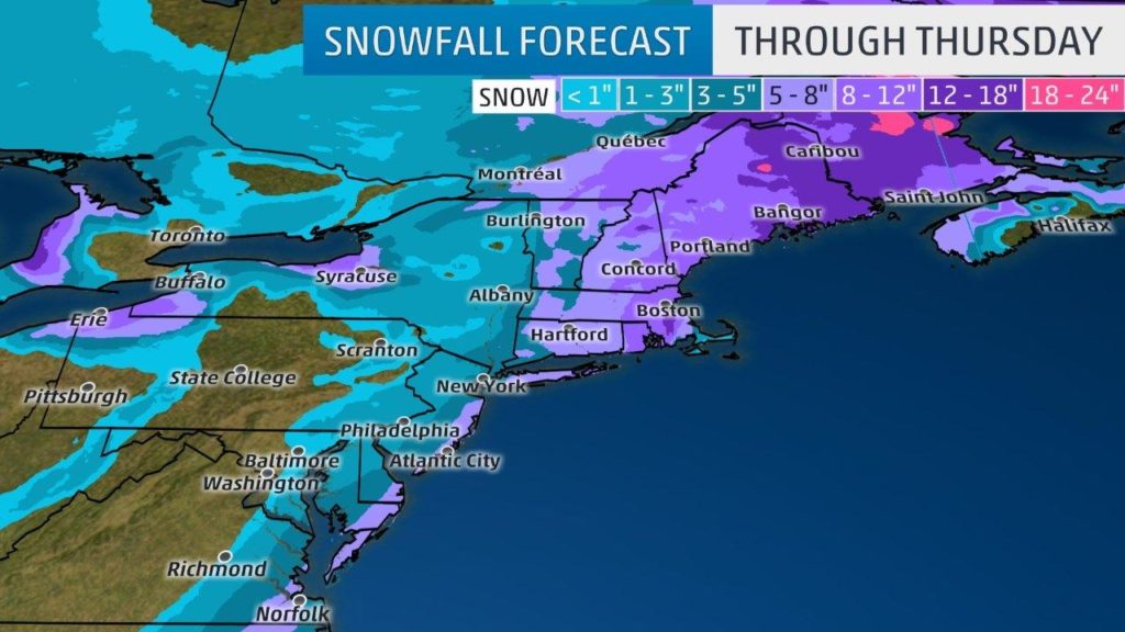
The National Weather Service said early Wednesday that blizzard-like conditions are possible in Suffolk County and parts of southern Connecticut between 1 a.m. Thursday and early Friday. Forecasters predict 5 to 10 inches for those spots, as well as for New Jersey’s Ocean County, with a foot or more possible in isolated locations. Wind gusts of 45 to 50 mph will cause drifting and poor visibility.
Some snowfall is also likely in New York City, but actual snowfall amounts will depend on the track of the storm. AccuWeather says the city will likely fall in the 1-3 inch range, and given the timing of the storm, even that amount could have a big impact on the morning commute.
Sunshine returns on Friday and Saturday, but it’ll be windy and brutally cold with highs only in the lower teens. The wind chill will make it feel well below zero.
Thursday-Thursday night
The powerful storm will be centered off the Northeast coast. Given its large circulation and strong intensity, the low will likely produce snowfall, possibly heavy, in parts of the Northeast region.
Snowfall may spread from the Virginia Tidewater to the New York City metro and much of New England during the day.
Increasing winds are likely along much of the Northeast coast. Wind gusts stronger than 50 mph are possible along the immediate coasts of North Carolina (Thu AM), New England (Thu PM) and Atlantic Canada (late Thu PM into early Fri AM) depending on the exact track of the low-pressure system.
Wind gusts 60-70 mph are possible on Cape Cod and for the Massachusetts islands. Power outages are likely.
The winds will likely cause some power outages along the immediate coast of New England, which would be followed by very cold temperatures Friday-Saturday.
Near-blizzard conditions could occur in eastern New England and eastern Long Island.
A storm surge of several feet is likely along north-facing coastlines in eastern Massachusetts on Thursday.
Gusts to 75 mph are possible more than 20 miles offshore coastal Massachusetts, and seas could climb above 26 feet. Boating is strongly discouraged.
Overnight Thursday, most of the snowfall from this storm will be confined to parts of New England.
(AP)
 Join the official YWN WhatsApp status


One Response
The National weather services is saying 4-7 inches for NYC and according to a computer model called the NAM we may get between 1 to 2 feet even in the city