
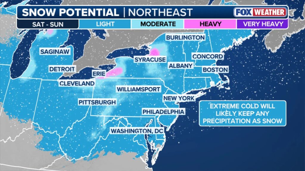
A new blast of Arctic air is barreling toward the central and northeastern United States, and it could bring the region’s first bona fide snowstorm of the winter, setting up a volatile weekend across one of the country’s most densely populated corridors.
Meteorologists say a weakening Polar Vortex — the high-altitude cold-air system that typically locks frigid air near the poles — is poised to spill brutally low temperatures into the Midwest and Northeast starting Saturday. If the advancing cold syncs with a fast-moving storm crossing the country and enough moisture surges north from the Gulf, forecasters warn that the I-95 corridor could wake up to heavy snow by Sunday.
The setup is classic, if precarious: cold air dropping in from Canada, a Pacific storm system racing east, and a potential coastal low that could rapidly intensify. But any missing piece — a more limited moisture feed, a weaker jet interaction, or a smaller cold-air push — could dramatically scale down snowfall totals, especially for major cities on the coast.
For now, model guidance suggests snow developing in the Midwest early Saturday before sweeping eastward. If conditions cooperate, the Northeast’s largest cities — New York, Philadelphia, and Boston — could see their first significant snowfall after an unusually mild start to December.
The looming pattern shift comes on the heels of record-setting cold in parts of New England, and it aligns with NOAA’s earlier warnings that La Ni�a could drive a more active early winter.
Still, forecasters are cautious. With several atmospheric variables in play, confidence remains low.
If the system comes together, the Northeast could be in for a fast, disruptive reminder that winter has arrived. If not, the region may dodge another early-season bullet.
(YWN World Headquarters – NYC)
 Join the official YWN WhatsApp status


4 Responses
Another January 1st 1996? Slim chance
Blah blah blah
Didn�t they say the same last week and it was all rain?
Ah, The. Blizzard of 96. Brings back memories.
Maybe we�ll get a white Chanukah!!