
Blizzard Warnings issued: The National Weather Service has issued Blizzard Warnings for nearly 30 million Americans from Boston to New York City to Atlantic City to Delaware and Maryland.
“Monster” snow totals: Forecast confidence is surging for a historic event. Some models are now painting more than two feet of snow for parts of New Jersey, while the broader I-95 corridor from Philly to Boston is bracing for 12-24 inches.
Whiteout conditions: Once the storm “bombs out” on Sunday, 50-60 mph wind gusts will combine with snow rates of 1-3 inches per hour to create total whiteout conditions.
Coastal crisis: Along with the snow, coastal flooding and significant beach erosion are expected. A Storm Warning is in effect for coastal waters, with breaking surf threatening shoreline structures.
Power outage risk: Due to the heavy, wet nature of the initial snow and the extreme wind gusts, widespread and prolonged power outages are considered a high probability for the I-95 corridor.
Travel nightmare: Airlines have already canceled hundreds of flights through Monday with blizzard conditions expected to bring Northeast air travel to a halt.
Blizzard Conditions Possible Sunday Night into Monday
The worst of the storm arrives late Sunday afternoon and lasts through sunrise Monday. Snowfall rates could reach 2-3 inches per hour, with strong winds creating whiteout conditions – especially along the coast. The storm’s central pressure off the coast will rival that of a category 2 or 3 hurricane. This strengthening will collapse in colder air and change all precipitation to heavy snow.
Blizzard Warnings are in effect for:
Long Island
All five boroughs
Westchester and Rockland counties
Coastal Connecticut
Much of New Jersey
A Blizzard Warning means winds or gusts will hit or exceed 35 mph along with blowing snow, with visibility knocked down to 1/4 mile or less for three hours or more.
Winter Storm Warnings cover the rest of the region.
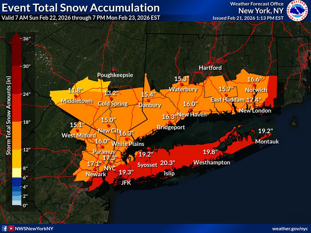
By the time the storm pulls away Monday, much of the area is expected to see 12-18 inches of snow, with locally higher totals over a foot likely across the East End and parts of the Jersey Shore. Some areas could see over 20 inches east and south of New York in heavy bands where to 2 to 3 inches of snow fall for 6 to 8 hours.
FOX FORECAST CENTER SNOW TOTALS
Boston 18-24″
NYC 18-24″
Jersey Shore 2ft+
Philly 18-24″
Baltimore 8-12″
DC 5-18″
 Join the official YWN WhatsApp status


4 Responses
Will someone wake up AL Gore?
Global warming at its best
After the great City response last time I could safely say more people are going to die from this two feet of snow
I was in EY in 2017. My flight back was delayed several hours. But in the end that blizzard was a bust. In the end we had only several inches of sleet.