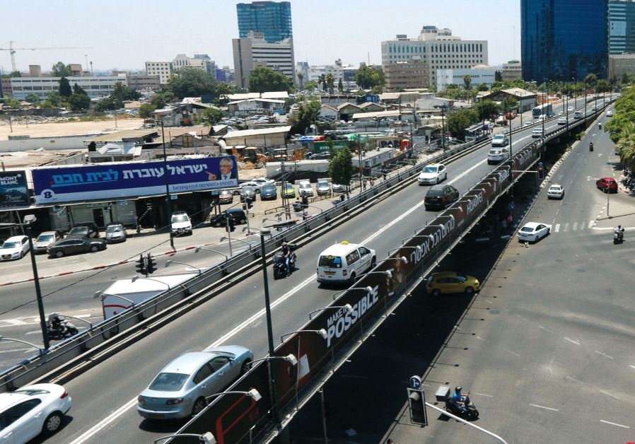
This is going to be quite challenging for veteran drivers, but the Ministry of Transportation is forced to adjust the numbers of new roads due to the many changes.
Over the next two years, about 2,000 signs will be replaced throughout the country, according to the new numbering of roads set by the Ministry of Transportation. Where possible, new stickers will be affixed to the existing signs. The work will be performed by the operations and maintenance division of Netivei Israel. Each time a change is made, the information will be transferred to the popular Waze application, which will make it easier for the drivers to get to know the new road names.
According to the report in Yediot Achronot, Transport Minister Yisrael Katz explained that over the past decade hundreds of kilometers of new roads have been built on the interurban road network in Israel. Hundreds of interchanges, tunnels, bridges and tracks were also built.
“In order to make it easier for drivers to take advantage of the new road network, and to enable them to navigate the extended network, a comprehensive change has been made to the road map in Israel, with new road numbers added and existing road sections were updated according to the numbering system and the new network,” explained Minister Katz.
The Ministry of Transport reassures that the new method will also preserve the current principle that major roads at the national level are marked by a single number and excellent inter-district roads in a double number. Major lengths crossing a large number of districts shall be indicated by a double number ending in zero (40, 60, etc.). Smaller regional roads are marked with three digits, and local roads are four. Roads across the country (from west to east) will be marked in odd numbers, while longitudinal routes (from north to south) – in even numbers. Finally, the numbers are increasing, respectively, from west to east and from south to north (Highway 2 is more western than Route 4, and so on).
According to the new method there will be no numbers for roads that get cut off or continue in a different place, as was the case until now. Another change would prevent a situation where there is a common road segment for two different road numbers. And another innovation: so far fast roads connecting large cities began in the middle of one city and ended in the middle of another city. Now the number of the road will relate to the section entering the city to enter the other city, while the sections from the entrance to the center will be simply named by their street names. To illustrate: Road 2 reaches Tel Aviv, and from the entrance it becomes Namir Road and its number is irrelevant.
So far three roads have been marked by three colors. As part of the revolution, the Transportation Ministry is moving to four colors: blue – for a major highway; Red – a main road; Green – a road of a regional nature; And black to a local road used to access settlements. So far, many such roads had not had a number, and now they would be given four-digit numbers.
Roads surrounding urban metropolitan areas will be defined as “ring roads” and other road segments will be eliminated, using a uniform number. For example, it was decided to grant the “Kinneret ” Road the number 900. The route of the new road includes a series of roads using the current method, the old ones: 85, 90, 92 and 87. So one number replaces four numbers – simpler. Similarly, the ring road in Beersheva will be called Highway 28 and will connect to Route 25, 6, 30, 34 and 26.
Highway 90, the longest of Israel’s roads, will become Route 8. Highway 57, which also bypasses Kfar Yona, which is slated to be paved soon, will become Route 7. In addition, highways and main roads that have been upgraded in recent years will become two-numbers according to the volume of traffic. Highway 431 (from Rishon L’Tzion to Modi’in) will become Route 43, Route 443 (from the Ben Shemen interchange to the Maale Adumim) will become Route 45. Roads 412 and 461 (south of Tel Aviv to Bnei Atarot) will become Route 46; Route 471, (Route 531, from the Kfar Shmaryahu interchange on Highway 2 to the Chorshim interchange on Highway 6) will become Route 51, Route 553 (from the Poleg interchange in Netanya to the village of Ya’af in the Sharon) will become Route 59.
On the other hand, there are roads that have been decided to “downgrade” from a two-digit to three-digit road. For example, in the Jerusalem area, Highway 10 will become Route 110; Highway 12 (from Eilat to Shizafon Junction) will turn into Route 112; Route 13 would turn into Route 101; Route 73, connecting Nahalal and Mizra to the Jezreel Valley in the north, will turn into Highway 681; And Road 57 in Yehuda and Shomron will become Route 577.
According to the update, a double number of overlapping segments will be eliminated. For example, Highway 6 will cancel Route 70 in all the overlapping sections. The section of the road from Route 2 to the Tut interchange (near Yokneam) will become Route 67.
Also, non-contiguous road sections will be divided into several different roads to avoid confusion. Thus, for example, Route 60 (the mythical main road of Yehuda and Shomron) passes through the municipal area of Jerusalem and is divided into several sections following the transfer of part of the route to the authority of the Palestinian Authority. Therefore, in the new method, the number 60 will describe the road between Beersheva and the entrance to Jerusalem only. The section from Givat Binyamin (Adam, Hizme checkpoint) to Yitzhar will be called Highway 62; The section between Jenin and Afula will be called Route 712; and the section between Afula and Nazareth will become Route 68.
To make the change logical, the new update will adjust the number of roads to the importance and use of each road. In other words, if a large road has so far connected to the “small” road that reached the settlement, there are now situations in which the number of the small road will be canceled, and it will be part of the large road. For example, Highway 71 in the north will continue near the village of Yehezkel to Route 675 – and will cancel it, while the continuation of Route 71 today will reach Afula will become Route 711.
As mentioned, the process will take about two years and every time a change is made, it will be updated in Waze to make it easier for the drivers.
(YWN Israel Desk � Jerusalem)
 Join the official YWN WhatsApp status